San Francisco Real Estate District Map
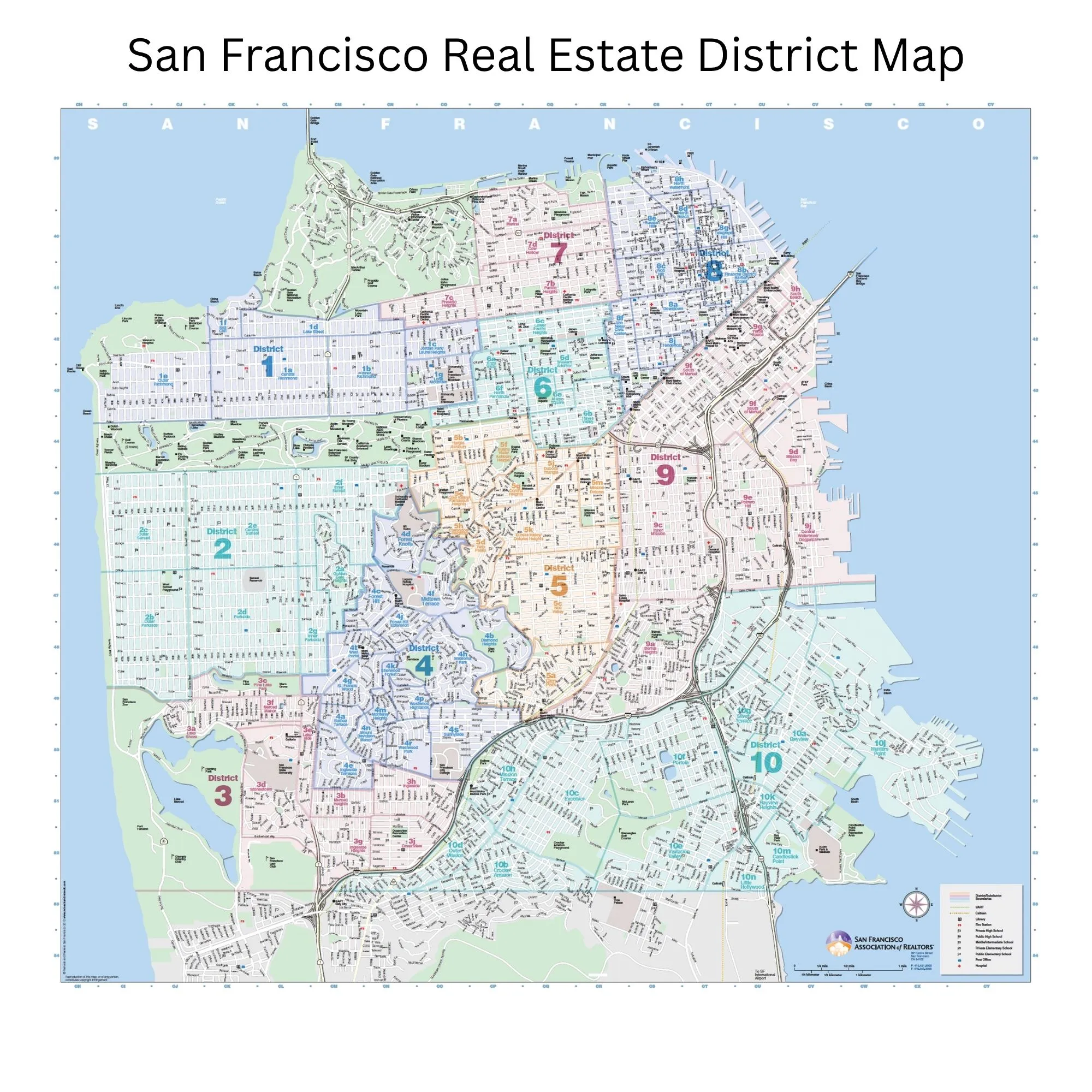
The San Francisco Association of Realtors divides the city into 10 numbered real estate districts and 89 neighborhood subdistricts. Search the interactive map below to find any neighborhood, see which district it belongs to, and open its local guide.
Interactive San Francisco District Map
Type a neighborhood name into the search box, or tap a district number to zoom in. Selecting a neighborhood shows its district and, for the 38 neighborhoods with a local guide, a link straight to it.
How San Francisco Real Estate Is Organized
Navigating San Francisco's real estate market starts with understanding the city's district system.
The San Francisco Association of Realtors (SFAR) divides the city into distinct districts and subdistricts that agents, buyers, and sellers rely on to describe location, compare pricing, and track market trends. Each numbered district corresponds to a specific area of the city, from the Sunset to Noe Valley to Downtown, which makes it easier to analyze market data and communicate clearly about where a home sits.
Whether you are preparing to list your home or searching for your next one, this page is a reference for how San Francisco's neighborhoods are organized in the MLS and where your home fits within that structure.
The 10 Districts and Their Neighborhoods
Each district groups together a set of neighborhoods. Jump to a district below, or scroll through all ten.
Richmond
District 1 covers the northwest corner of the city, anchored by the Richmond District, and is known for its proximity to Golden Gate Park, the Presidio, and Ocean Beach.
Sunset
The Sunset makes up most of District 2, a largely residential area known for cool coastal weather, wide streets, and easy access to the beach.
Lake Merced & SFSU
District 3 occupies the southwestern corner of the city around Lake Merced and San Francisco State University, and it has a more suburban feel than most of San Francisco.
Twin Peaks West
District 4 sits on the western slopes of Twin Peaks and Mount Davidson. It is one of the city's most upscale districts, known for well-kept homes and planned residence parks such as St. Francis Wood and Westwood Park.
Central SF
District 5 is home to many of the city's most sought-after neighborhoods, including Noe Valley, the Castro, Cole Valley, and Glen Park, and it is prized for its central location and strong neighborhood character.
Central North
District 6 is a mix of historic, centrally located neighborhoods such as Hayes Valley, Alamo Square, and Lower Pacific Heights, known for Victorian architecture and easy access to downtown.
North / Marina
District 7 includes some of the most prestigious neighborhoods in San Francisco, among them Pacific Heights, Presidio Heights, Cow Hollow, and the Marina, known for their views and proximity to the bay.
Downtown
District 8 covers the northeastern corner of the city, including downtown, Nob Hill, Russian Hill, and North Beach, where condominiums and multi-unit buildings make up much of the housing.
Central East
District 9 is one of the most dynamic parts of the city, blending established neighborhoods like the Mission, Bernal Heights, and Potrero Hill with newer development in SoMa, Mission Bay, and Dogpatch.
Southeast
District 10 covers the southeastern neighborhoods of the city, known for sunnier weather and more attainable price points than much of San Francisco.
Which District Is My Neighborhood In?
All 89 San Francisco neighborhoods recognized by SFAR, listed alphabetically with their district number.
The Official SFAR District Map
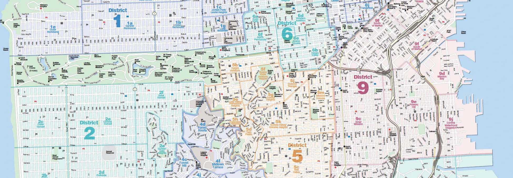
The official map published by the San Francisco Association of Realtors. Tap the image to open it at full size.
San Francisco Real Estate Districts FAQ
How many real estate districts are in San Francisco?
The San Francisco Association of Realtors divides the city into 10 numbered districts, which are further split into 89 subdistricts that correspond to individual neighborhoods. Listings and sales on the San Francisco MLS are organized by these districts and subdistricts, which is why agents, appraisers, and buyers use them to describe location and pull comparable sales.
Are SFAR districts the same as San Francisco supervisor districts?
No. The Board of Supervisors uses 11 supervisorial districts that are drawn for elections and redrawn after each census. SFAR districts are a separate real estate system with different boundaries and numbering, so District 5 on a ballot and District 5 in the MLS describe two different parts of the city.
Why do agents use districts instead of zip codes?
Zip codes were drawn for mail delivery, and a single zip code can span neighborhoods with very different housing and very different prices. SFAR subdistricts follow neighborhood lines instead, so comparing sales within a subdistrict gives a far more accurate picture of value than comparing sales across a zip code.
Does the district my home is in affect its value?
Location is one of the largest drivers of price in San Francisco, and the subdistrict is where an accurate pricing analysis starts. Adjacent subdistricts can trade at noticeably different levels, and the differences often continue down to the block, which is why a valuation built on the right subdistrict comparables is more reliable than a citywide or zip-code average.
How do I find out which district my home is in?
Search for your neighborhood in the interactive map above, or find it in the A to Z list. Every neighborhood shows its district number. If your home sits near a boundary, Oliver can confirm the exact district and subdistrict and show you the recent sales that are actually comparable.
Know Exactly Where Your Home Fits
With 23+ years and $350M+ closed across San Francisco and Marin, Oliver knows the micro-pricing dynamics that shift from one district, and one block, to the next. Let's talk about your home.
Districts and subdistricts reflect the San Francisco Association of Realtors (SFAR) MLS structure; map boundaries are SFAR subdistrict designations as published by the City and County of San Francisco (DataSF). All information is deemed reliable but not guaranteed and should be independently verified. Oliver Burgelman | CA DRE# 01388135.